


Mike's latest trail map is the Trail Map and Guide to Grand Monadnock with Gap Mountain and Surrounding Area, published in January 2011. This full-color Monadnock trail map, covering all trails on Monadnock and nearby Gap Mountain, is the most complete and detailed trail map of the area currently available. It is the only Monadnock trail map that has descriptions for every trail on the back, and the only one that folds to pocket size. It may be purchased by sending a check for $9.00 per map (includes return postage) to:
Lucimaps.com
P.O. Box 32
Montoursville, PA 17754-0032
Quantity discounts on this Monadnock trail map are available on packs of 10 maps, free delivery in New Hampshire. E-mail bulk-maps for information.
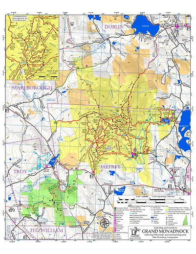
Features of this map:
-
Shows and describes every hiking trail on Monadnock with cumulative mileages
-
Includes Gap Mountain and through-trails
-
Trail segment mileages on map side
-
Ski trails, local businesses, landmarks, and viewpoints indicated with symbols
-
Shows all roads surrounding Monadnock
-
Shows winter status of roads and parking lots
-
Large, easy-to-read trail and road names
-
Full color with subtle shaded relief
-
1:24,000 scale (same as USGS quads) with detailed 1:12,000 scale inset
-
50' contour interval, dense contour numbering
-
Tough, waterproof, glare-free Tyvek with Tyvek envelope
-
Folds to convenient pocket size, easy partial unfolding
Mike also produced the Wonalancet Out Door Club Trail Map and Guide to the Sandwich Range Wilderness and environs in 2007. That map is available at www.wodc.org/map.htm.
To report errors or omissions in the trail map, e-mail bromberg@myfairpoint.net
Map errata reported:
1. Back side, "About This Map": URL for this page should be www.threeringcircuits.com/cartography
2. Wooden Josh Inn in Dublin and Grand View Inn in Jaffrey have closed.
3. Add waterfall symbols to Cascade Link and Mossy Brook Trail.
4. Start of Fairy Spring Trail has been restored to the original route described on the map.
5. Upper 0.1 mile of Old Halfway House Trail is closed due to erosion. Use Cart Path and Old Toll Road to reach the Halfway House clearing.
Tags: "Monadnock map", "Monadnock trail map", "Mt. Monadnock", "New Hampshire", "hiking", "trails"